|
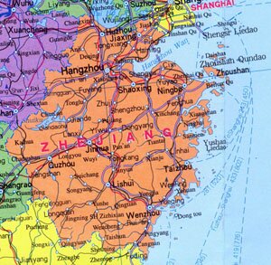
Zhejiang Province Overview
Zhejiang Province, abbreviated as Zhe or Dian in Chinese, is located in the coastal area of southeast China. It covers an area of over 100,000 square kilometers, and has a population of 46.02 million. The capital city of Zhejiang Province is Hangzhou.
Zhejiang Province Geography: Zhejiang's terrain gradually descends from southwest to the northeast, with low hills taking up most part of its total area. Major mountains are Mt. Xianxia Ling, Mt. Yandang Shan, Mt. Kuocang Shan, Mt. Tiantai Shan, Mt. Tianmu Shan and Mt. Huiji Shan. Marjor rivers are Qiantang River in the north and Qu River in the south.
Zhejiang Province Climate: Zhejiang enjoys subtropical humid monsoon climate, characterized with adequate sunshine and plenty of rainfall. With an annual rainfall of between 1,200 ~ 1,500 mm, the average annual temperature is between 15 ~ 19 ℃, and 3 ~ 8 ℃ in January and around 28 ℃ in July.
Zhejiang Province Agriculture: Agriculture in Zhajiang Province is highly commercialized. Zhebei Plain is traditionally a renowned land of abundance and produces large amount of jute and sile pods.
Zhejiang Province Industry: Zhejiang has diversified industrial system including metallurgy, machinery, chemicals, building materials producing, textile and food production.
Tourist Resources of Zhejiang Province: West Lake, Mt. Yandang, Mt. Putuo, Shengsi Island, Tianyi Ge, Mt. Mogan and Qiandao Lake.
|