|
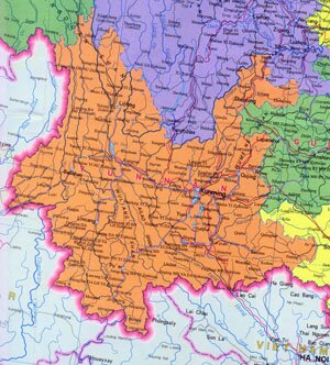
Yunnan Province Overview
Yunnan Province, abbreviated as Yun or Dian in Chinese, is located on the southwest of Yungui Plateau, southwest of China. It covers an area of over 390,000 square kilometers, and has a population of 42.70 million. The capital city of Yunnan Province is Kunming.
Yunnan Province Geography: Yunnan's terrain gradually descends from the northwest to the southeast and mountains and hills takes up 90% of its total area. Major mountains are Mt. Gaoligong, Mt. Nu and Mt. Yun Ling in the west and Mt. Wulian Feng, Mt. Wumeng Shan in the northeast. Majar rivers are Jinsha River, Lancang River, Yuan River and Nu River.
Yunnan Province Climate: Yunnan enjoys subtropical and tropical highland humid monsoon climate, characterized with blurry seasonal difference. With an annual rainfall of between 1,000 ~ 1,500 mm, the average annual temperature is between 13 ~ 20 ℃, and 8 ~ 12 ℃ in January and 18 ~ 24 ℃ in July.
Yunnan Province Agriculture: Yunnan encourages an all-round development in famring, foresty, animal husbandry, sideline occupations and fishery. Yunnan's tobacco producing leads in China.
Yunnan Province Industry: Yunnan si very famous in China for its productions of copper, tin and lead.
Tourist Resources of Yunnan Province: Dianchi Lake, the Stone Forest, xishuangbanna National Nature Reserve, Old Town of Lijiang, Three Paralle Rivers and etc.
|