|
Hong Kong Overview
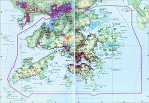
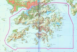
Hong Kong Special Administrative Region, abbreviated as Gang in Chinese, is located to the east of Zhu Jiang River Estuary, made up of Hong Kong Island, Kowloon, New Territories and some other separate islands. It covers an area of over 1,103 square kilometers, and has a population of 6.99 million. The SAR government is stationed on Hong Kong Island.
Hong Kong Geography: Hong Kong is featured with hills, islands and bays. Among its islands, Lantau Island is the largest one and Hong Kong Island is the second largest.
Hong Kong Climate: Hong Kong enjoys a a subtropical marine monsoon climate, characterized with frequent typhoons, storms and plenty of rain. With an annual rainfall of 2,200mm, the average annual temperature is between 23℃, and 152℃ in January and February and 28℃ in July and August.
Hong Kong Economy: Hong Kong is believed to be the tranportation hub of southern Asia, Europe, America and Oceania. Well developed in processing, trade and finace, it is known as the Oriental Pearl and the Paradise for Shoppers and Tourists. Hong Kong's Agriculture is mainly consists of by-products production, fishery and horticulture. Trade and logistics, financial services, tourism and other producer services are the four backbones of Hong Kong.
Tourist Resources of Hong Kong: Ocean Park, Taiping Moutain, Qingshan Temple, Tian Tan Buddha, Hong Kong Disneyland, Lantou Island, Repulse Bay, Standley Market, Avenue of Stars etc.
|